Mayo Galway Border Shift 1898
The following I got from Pete Schermerhorn, in the glorious Berkshire hills of western Massachusetts, to whom I am indebted:
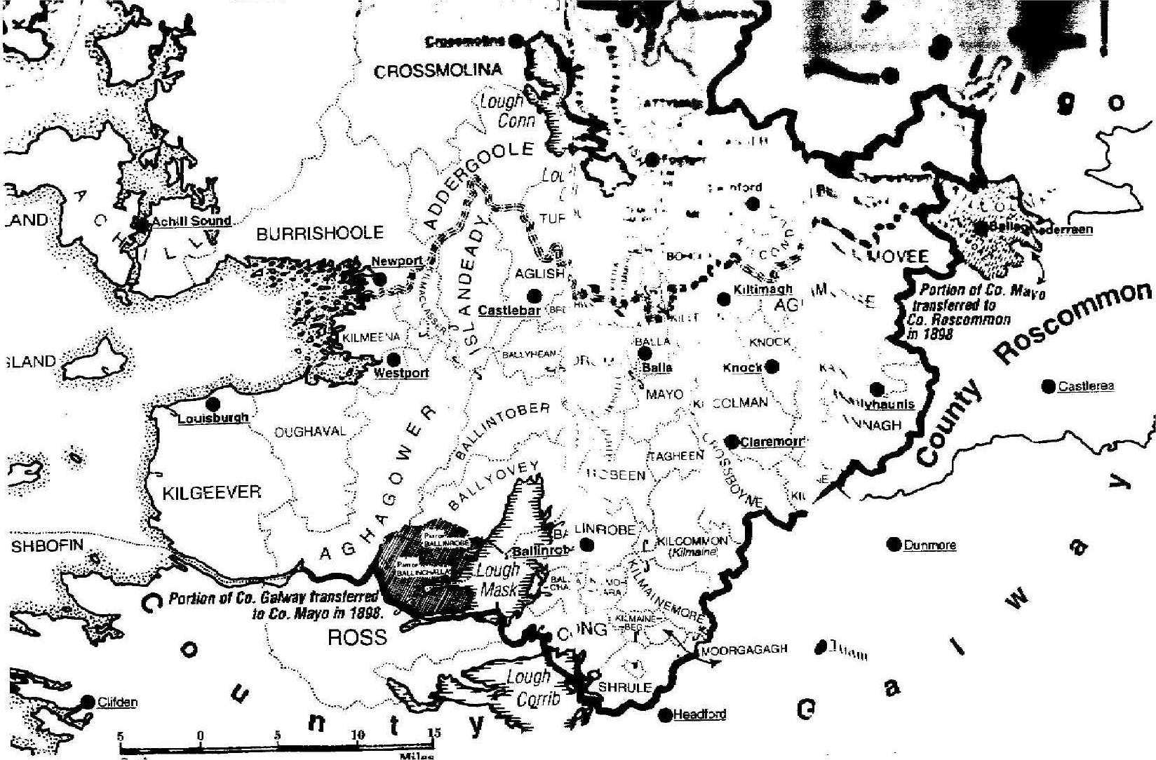
The border change occurred in 1898. The line along the western shore of Lough Mask started just north of Churchfield Lower, and south of Cappaghduff and Tourmakeady. So Churchfield did change, Tourmakeady did not. The line of change runs more or less westward from just above Churchfield, and included Garranagerra (but not Derryveeny), Lettereeneen, and over to about Lough Glenawough and then down to the current northward bump in the boundary, at Maumtrasna, just north of Lake Nafooey. The probably uninhabited townlands of Barnahowa, Dirkbeg and Cappanacreha were also included in this boundary shift.
[NOTE - I know Barnahowna was inhabited, many of my people are from there.]
The line, going the other way, went from above Churchfield south into Lough Mask and continued to the current jog in the border line off of Saint's Island, about two miles north of Clonbur, where it rejoined the border.
So the chunk of land "donated" to Mayo from Galway in 1898 included such places as Churchfield, Trean, Killateeaun, Srahnalong, Cummer, Glenbeg, Finny and Kilbride, etc.
That's less than a thousand words, but I hope it paints an adequate picture. If you had a Discovery Map 38, I could give you some coordinates......but what I've written should be good enough (I hope).
From Ivor Hamrock, of the Mayo library:
Churchfield was in the civil parish of Ballinrobe. Most of the parish was in County Mayo, but part of it extended into County Galway and this included Churchfield. When the Poor Law Unions were set up in 1838 the Union of Ballinrobe extended into Galway and included Churchfield. In the Townland Index of 1861, the entry for Churchfield is given:County Galway, Barony of Ross,Civil Parish of Ballinrobe, Poor Law Union of Ballinrobe.
On the first of November 1898 the Local Government Board made a number of changes to some county boundaries including Mayo and Galway. The District Electoral Divisions of Ballinchalla and Owenbrin were transferred from Galway to Mayo. Churchfield is in the D.E.D. of Ballinchalla and was thus transferred into Co. Mayo.
The reason I wanted to clearly define this is that my McGings settled in Churchfield, which was Galway up until my grandfather was born, when it became Mayo. And while I've been focusing on Mayo in my research, this shows that Galway sources may also need to be consulted.